The 'Impossible Trinity' of Optical Remote Sensing Pushed to Its Limits by Chinese Satellites
 05/20 2026
 502
502
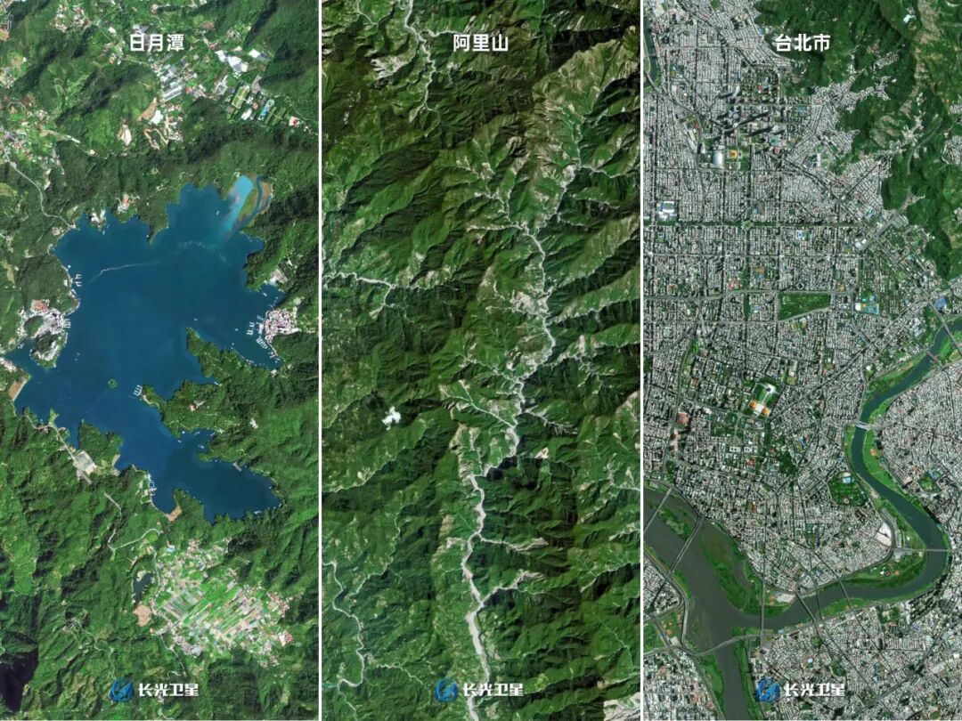
01 A Photo and the 'Bird’s-Eye View of Home'
October 25, 2025, marked the first Taiwan Retrocession Day.
The commercial satellite 'Jilin-1' released multiple high-definition satellite images of Taiwan Island. Sun Moon Lake’s surface, Alishan’s treeline, Taibei Port’s docks, and the factories of Hsinchu Science Park were clearly visible from space. The photos spread widely across social media platforms on both sides of the strait, with netizens commenting that every street was visible, akin to looking down from an upstairs window at home.
Days later, at a State Council Taiwan Affairs Office press briefing, spokesperson Zhang Han delivered a memorable response that went viral:
'This is a bird’s-eye view of home.'
The significant impact of a single satellite photo stemmed not from the sophistication of remote sensing technology but from its capture of the map in everyone’s hearts.
This confidence comes from resolution. Jilin-1’s highest resolution surpasses 0.5 meters, capable of discerning objects as small as 0.5 meters from 500 kilometers above.
Impressive, right? Here’s another story: In 2024, the phrase 'Serve the People' inscribed in the Gobi Desert near Hami, Xinjiang, was vandalized. Several netizens drove over 2,000 kilometers to repair it. After completion, they sought to verify the results but faced a temporary drone flight ban. They then purchased Jilin-1’s overpass imaging service, and the satellite duly captured and returned photos, making the repair effectiveness clear.
Seeing the ground clearly from space is no longer the privilege of a few institutions.
02 The Impossible Trinity: A Dilemma of Choosing Two
The principle of optical remote sensing satellites is essentially no different from that of a smartphone camera. Both use lenses to collect visible light or near-infrared and other multispectral bands, focusing them onto sensors to generate images. The difference lies in perspective: a phone captures what’s in front, while a satellite captures the ground 500 kilometers below.
Photographing from 500 kilometers away is no simple feat; it requires three interdependent performance metrics.
Resolution determines the smallest discernible object. A 0.5-meter resolution means a 0.5m × 0.5m area on the ground corresponds to one pixel in the image; objects smaller than this merge into the same pixel. At 0.5-meter resolution, a car is distinguishable, but facial expressions are not.
Note: Satellites typically report two resolutions: panchromatic (black and white, higher) and multispectral (color, usually 2–4 times lower). The 0.5-meter, 0.75-meter, etc., figures mentioned later refer to panchromatic resolution.
Swath width indicates how much ground area a single photo can cover. A wider swath increases the area captured per shot, boosting efficiency. However, swath width and resolution are inversely related; a lens has a fixed aperture, so prioritizing resolution compromises swath width, and vice versa.
Revisit period refers to how often the same location can be photographed again. For commercial users, this is the most valuable metric. When did the corn turn yellow? When did the port containers suddenly pile up? Only frequent imaging renders such data meaningful.
Two definitions of revisit period are often conflated and must be distinguished:
Definition 1: Single-satellite orbital period. A satellite completes one orbit around Earth in approximately 90–120 minutes (~15 orbits per day). This is governed by physics and unrelated to satellite design.
Definition 2: Constellation revisit capability. With multiple satellites working in tandem, how many times per day, on average, can a location be imaged? More satellites mean more frequent revisits.
The 35–40 revisits mentioned herein follow Definition 2, the metric that truly matters to commercial users.
Herein lies the problem: You can excel in at most two of these three metrics simultaneously. This is the 'Impossible Trinity' of the optical remote sensing industry.

Jilin-1 is pushing this trinity to its limits through scale. To be clear, the trinity’s framework remains intact; physical laws still apply. However, by continuously increasing its on-orbit satellite count, Jilin-1 has elevated both high frequency and high resolution to usable levels—a feat no other entity has globally achieved.
03 Global Approaches: Planet, Maxar, and China’s Choice
Satellite companies share a common goal: make satellites smaller, lighter, cheaper, while improving resolution.
Approach 1: Many, but not clear.
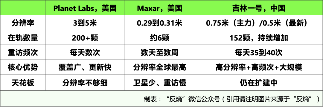
US-based Planet Labs is the world’s largest operator of remote sensing constellations, with over 200 on-orbit satellites but only 3–5-meter resolution. This precision can discern a forest or a neighborhood but not individual trucks or their cargo. Its business model emphasizes broad coverage and low pricing. If you need to monitor a vast area, like farmland across an entire province, Planet Labs is the most cost-effective choice. However, it cannot provide finer details.
Planet has begun launching its Pelican series of high-resolution satellites, designed for better than 0.30-meter resolution, but as of May 2026, they remain in testing and have not yet formed a scalable commercial service.
Approach 2: Clear, but few.
Represented by US-based Maxar, its WorldView series achieves 0.29–0.31-meter resolution, the highest globally for commercial optical remote sensing. However, the entire WorldView Legion constellation plans just six satellites, with four launched by 2025. Fewer satellites mean longer revisit periods; a location might only be reimaged every few days or weeks. High-priority areas can achieve shorter intervals through orbital scheduling, but this is not a globally uniform capability. Maxar’s model targets high precision and high pricing, with military and intelligence agencies as primary clients.
Both approaches have reached their limits.
Beyond these two, the US military’s NRO operates reconnaissance satellites with resolution potentially better than 0.1 meters, but these are not commercially available. Emerging companies like BlackSky pursue rapid-response routes but still cannot simultaneously surpass the preceding two in both on-orbit scale and high resolution.
In essence, the US commercial optical remote sensing market is divided between 'many but not precise' and 'precise but not many,' with no one achieving high-definition, high-frequency, and large-scale commercial viability.
Approach 3: All three.
In China, as of April 2026, Jilin-1 has 152 on-orbit satellites, with a target of 300 by the end of 2027. Its main on-orbit satellites offer 0.75-meter resolution (GF03D series), while the newly launched GF05 and Wide-Field 02B series achieve 0.5-meter panchromatic resolution and are gradually entering orbit. Reports suggest the GF05 series can reach 0.2-meter panchromatic resolution, capable of counting people in the Forbidden City’s square.
In terms of revisit frequency, it achieves 35–40 daily passes over any global location, dynamically adjusted based on on-orbit numbers. Single-satellite swath widths exceed 17 kilometers, with wide-field models reaching over 150 kilometers, further enhanced by constellation coordination.
Now, let’s compare:
The results are clear.
Currently, only Jilin-1 globally combines sub-meter resolution, high-frequency revisits (35+ daily), and large-scale commercial constellations.
04 Four Leaps: From 420 kg to 20 kg
Achieving 'high-definition + high frequency + large scale' required not a sudden breakthrough but a clear technological evolution. Jilin-1’s constellation has traversed this path, making it an ideal case study.
The core strategy: make satellites smaller, lighter, cheaper, while improving resolution. This journey involved four key leaps.
First leap (2015): From zero to one.
China’s first commercial high-resolution optical remote sensing satellite, Jilin-1 Optical A, launched successfully at 420 kg with 0.72-meter panchromatic resolution. A Long March 2D rocket’s SSO capacity is ~1.3 tons, so launching a 420 kg satellite wasted most of its capacity. Heavier satellites also mean higher launch costs.
Second leap (2017–2019): Weight reduction exploration.
Subsequent models launched with decreasing weight and improving resolution but lacked mass production; each satellite was individually designed and produced.
Third leap (post-2020): Platform breakthrough to 20 kg.
The true weight breakthrough came with the Platform 01A series, reduced to 20 kg—over 20 times lighter than the first-generation Optical A. The GF03D series, based on this platform, maintained lightweight design advantages, achieving 0.75-meter resolution and over 17 km swath width per satellite. At 20 kg, a single rocket could launch multiple satellites at once, drastically cutting launch costs.
Fourth leap (post-2023): Resolution advanced to 0.5 meters.
While maintaining lightweight design, the GF05 and Wide-Field 02B series further pushed panchromatic resolution to 0.5 meters. In October 2025, Chang Guang Satellite announced plans to launch 20 0.5-meter high-resolution satellites. By April 2026, with new satellites in orbit, the total reached 152.
From 420 kg to 20 kg, from 0.72 meters to 0.5 meters, from single launches to dozens per rocket, this technical route has significantly advanced the 'Impossible Trinity' of optical remote sensing over nearly a decade.
A constellation of 152 sub-meter-resolution satellites now achieves 38–40 daily revisits over any global location, with a target of 300 by the end of 2027, solidifying the high-resolution + high-frequency + large-scale combination.
05 Data in Action: More Than 'Pretty Pictures'
Who uses the images captured by satellites?
Agriculture is the largest application area for remote sensing data.
Healthy crops and those affected by pests or diseases reflect light differently. Multispectral satellites capture near-infrared, red-edge, and other bands beyond visible light, using spectral differences to assess crop health, estimate yields, and even detect early signs of pests or diseases before human eyes notice anomalies. Major agricultural nations worldwide use this logic for crop yield estimation, insurance claims, and trade decisions.
Finance may be the most unexpected field for ordinary people.
Hedge funds and trading firms abroad already incorporate remote sensing data into investment models. Parking lot traffic density can predict retail performance; changes in port container stacks can forecast import/export data; shadow lengths on oil tank storage tanks can estimate oil inventories. This aligns with the financial applications mentioned in our previous SAR article—optical and SAR remote sensing ultimately serve the same purpose through different means.
Urban planning once relied on field visits.
How have illegal structures, construction progress, or traffic flows changed? Now, satellites regularly pass overhead to capture images, which AI automatically compares to detect differences, boosting efficiency by orders of magnitude over manual inspections.
Environmental monitoring often sees satellites, not patrols, as the first to detect forest fires.
Optical satellites can locate fire spots and track spread directions within hours of ignition, providing critical intelligence for firefighting commands. However, once a fire rages, smoke obscures optical satellites’ view, necessitating SAR satellites, whose microwaves penetrate smoke for continuous imaging. Optical satellites detect fires first; SAR satellites track them throughout. Together, they form complete disaster monitoring capabilities.
This explains why our commercial satellite series began with optical and SAR remote sensing—they are not isolated topics but two means to the same end.
06 Landscape and Path: China’s Breakthrough in Optical Remote Sensing
China’s optical remote sensing competition can be roughly divided into three tiers.
Tier 1: Commercial leader. Jilin-1 (Chang Guang Satellite), with 152 on-orbit satellites and a target of 300. Its core strengths are first-mover advantage and mass production capabilities.
Tier 2: State-backed entrants. Gaojing-1 (operated by China Siwei/CASC), planning dozens of sub-meter-resolution satellites. The state’s involvement elevates optical remote sensing to national data infrastructure.
Tier 3: Multiple commercial firms following. PIESAT’s Nuwa constellation, primarily SAR-focused but incorporating optical components, pursues a dual SAR+optical model. Several other emerging companies are deploying their own commercial optical remote sensing constellations, continuously expanding the sector’s participants.
Planet Labs’ approach is many satellites, low price, broad coverage; Maxar’s is high precision, high value. Both have merit but face inherent limits.
China’s path can be summarized as high frequency + low cost + large scale. Rather than simply following existing routes, it leverages its complete industrial chain and scalable manufacturing capabilities to reduce costs through mass production, increase revisit frequency through scale, and advance both 'high-definition' and 'many satellites'—two traditionally conflicting goals—simultaneously through lightweight design.
To reiterate, Jilin-1 is the most prominent example of this path but not the sole player. Gaojing-1, Nuwa constellation, and several upcoming commercial constellations collectively form China’s Earth observation system.
Optical and SAR remote sensing are the two eyes of Earth observation—one relies on visible light, the other on microwaves; one sees clearly by day, the other around the clock; one is hindered by clouds, the other unaffected by weather.
Next, we’ll discuss communication satellites: Once seen, how is data transmitted back? With Starlink boasting over 10,000 on-orbit satellites and 9 million users, what is China’s response?
Sources for core data in this article:
【1】October 25, 2025/Multiple cross-strait social media/Jilin-1 releases high-definition satellite images of Taiwan Island
【2】November 5, 2025/State Council Taiwan Affairs Office press briefing/Spokesperson Zhang Han responds with 'bird’s-eye view of home'
【3】October 27, 2025/People’s Daily WeChat account/What is Jilin-1, the satellite overlooking Taiwan?
【4】2024/People’s Daily WeChat account/Repair of 'Serve the People' inscription in Hami, Xinjiang, and Jilin-1 overpass imaging
【5】April–May 2026/Sohu, Sina, MSN, CCTV Finance/Jilin-1 reaches 152 on-orbit satellites
【6】April 2026/Jilin Provincial Government website, Guancha.cn (December 2024)/~35–37 revisits at 117 satellites
【7】April 2026/Industry reports estimate/Approximately 38-40 revisits for 152 satellites at a time
【8】Chang Guang Satellite official website/Product page/Jilin-1's highest resolution is better than 0.5 meters
【9】Planet Labs official and industry reports/Over 200 satellites in orbit with a resolution of 3-5 meters
【10】May 2026/Planet Labs official public information and industry reports/The design resolution of the Planet Pelican series is better than 0.30 meters, under testing
【11】Maxar official public information and industry reports/WorldView Legion resolution 0.29-0.31 meters, 4-6 satellites in orbit
【12】Comprehensive public information/The resolution of the US NRO reconnaissance satellite is better than 0.1 meters, not available for commercial use
【13】Comprehensive public information/BlackSky, an emerging remote sensing company
【14】Chang Guang Satellite official website jl1.cn/Company established on December 1, 2014
【15】Satellite Encyclopedia huijiwiki.com/The first-generation optical satellite A weighs 420kg with a resolution of 0.72 meters
【16】Industry reports from websites such as Sciencenet/Platform 01A weighs in the 20-kilogram class
【17】Chang Guang Satellite official website product page/High-resolution 03D series resolution 0.75 meters
【18】Chang Guang Satellite public information and industry reports/High-resolution 05 series and wide-format 02B series resolution 0.5 meters
【19】October 2025/MSN, technology media reports/Launch a batch launch plan for 20 satellites with a resolution of 0.5 meters
【20】Chang Guang Satellite public plan/Target to reach 300 satellites by the end of 2027
【21】Industry reports/Jilin-1 high-resolution 05 series full-color 0.2-meter resolution
【22】Comprehensive public information/SuperView-1 (China Siwei/Aerospace Science and Technology Corporation)
【23】Comprehensive public information/PIESAT Nuwa constellation SAR+optical dual-mode
The data is current as of May 2026, and some planned data are subject to the latest official announcements.
-
![]()
Personnel Shuffle: Independent Director Mi Xuming Steps Down from OFILM
-
![]()
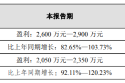
Net Profit Anticipated to Skyrocket by 103%: What Gives This Optical Company a Competitive Edge?
-
In Just One Year, China Unveils Unicorns Valued at 10 Trillion Yuan!
-
![]()
6 Park Companies Shine at WAIC: How Hong Kong Science Park Bridges AI from Research to Industry
-
![]()
Wang Wenjing’s Third Act: Can Yonyou Reinvent Itself in the AI Era?
-
![]()
Performance Coupe Entry Threshold Reduced to 170,000 Yuan: Assessing the 2027 Exeed ES's Prospects
-
![]()
Battery "Crisis" for 4 Million New Energy Commercial Vehicles
-
【Focus】Fluorinated Photosensitive Polyimide (FPSPI): A High-End Subdivision of PSPI with Great Potential in High-Tech Industries