How Autonomous Driving Achieves Time Synchronization Between LiDAR and Cameras
 02/09 2026
 529
529
For autonomous vehicles, perceiving the world involves more than a single approach. Typically, a combination of multiple sensors—including LiDAR, cameras, millimeter-wave radar, and Inertial Measurement Units (IMUs)—is employed to gather information about the traffic environment. These sensors operate in distinct ways and at varying frequencies, continuously collecting external data. To ensure accuracy in perception, meticulous attention is given to time synchronization when processing this data.
Why is 'time synchronization' important?
Time synchronization is vital because each data frame from different sensors carries a time label (timestamp). If these timestamps are misaligned, combining data from various sensors to perceive the environment will lead to inaccuracies.
Consider a simple example: A camera captures an image instantaneously, with all pixels in the frame representing the scene at that precise moment. In contrast, LiDAR generates point cloud data by rotating and emitting laser pulses to scan the surroundings, a process that may take tens or even hundreds of milliseconds per full rotation. If we directly combine a camera image with a LiDAR point cloud without accounting for the time difference, inconsistencies between the image and the point cloud are likely to arise, particularly when the vehicle is moving at high speed or when dynamic objects (such as pedestrians or bicycles) are present in the scene. These inconsistencies become more pronounced under such conditions.
For the perception module in autonomous driving, such time discrepancies create a 'partially lagging' view of the world, which can easily lead to misjudgments and decision errors. The goal of time synchronization is to align data from different sources so that they accurately represent the same moment in time.
In autonomous vehicles, cameras and LiDAR are among the most commonly used sensors. To discuss their time synchronization, it is essential to understand the differences in how they collect data.
Camera imaging is an 'instantaneous' process. Once the shutter opens and closes, all pixels in that frame are captured at approximately the same time (although this also depends on the camera's shutter mode, such as rolling shutter versus global shutter, which introduce minor differences; fundamentally, 'one exposure equals one frame').
LiDAR, on the other hand, acquires distance information by emitting laser pulses, receiving reflected signals, and calculating time differences. To achieve a full 360° view, it continuously rotates or performs mechanical scanning. During one rotation, some points are collected at the beginning, while others are collected at the end, resulting in time differences within a complete point cloud.
When attempting to align a specific image frame with a specific point cloud frame, if the camera captures an image at a particular moment while the LiDAR point cloud contains data from tens of milliseconds before and after that moment, even simple matching based on the 'closest timestamp' can introduce significant errors. Time misalignment complicates subsequent fusion algorithms, such as object detection and localization, which require corresponding image and point cloud features to be aligned for accurate position and category calculations. Time synchronization aims to reduce such temporal discrepancies to an acceptable range.
Hardware-Level Time Synchronization
In autonomous driving systems, one of the most reliable ways to achieve time synchronization is at the hardware level, aiming to have different sensors share a common time reference. Simply put, this means having all sensors operate on the same clock.
1) Unified Clock Source
The most fundamental method for time synchronization is to provide all sensors with a common time source. This can be the time signal from GPS or a high-precision clock on the vehicle's main control computing unit. Many autonomous driving systems use GPS's 1PPS (pulse per second) signal combined with IEEE 1588's PTP (Precision Time Protocol) for synchronization.
The GPS 1PPS signal emits a pulse every second, providing a highly accurate time reference. Sensors can use this signal as a reference moment and adjust their internal clocks accordingly. PTP, on the other hand, provides precise time synchronization at the network level, allowing devices on the vehicle's Ethernet network to align their times accurately. This way, LiDAR, cameras, IMUs, and other sensors can all place their timestamps on the same timeline.
Hardware-level unified clocks make it nearly impossible for time differences to accumulate into significant errors, ensuring that all modules perceive the world at the same time. However, issues such as network delays and hardware clock drift are inevitable.
2) Hardware Trigger Signals
Another direct approach is to use hardware triggers, where one sensor sends a trigger signal to control data collection by another sensor. For example, when the LiDAR rotates to a specific angle, it can trigger a signal for the camera to capture an image at that exact moment. This ensures that certain angles in the point cloud correspond precisely to the moment the image was taken.
This method allows two sensors to collect data simultaneously in response to the same external event. Its advantage lies in strong time consistency without the need for complex time protocols. However, its drawback is that it is event-specific and may not suit all scenarios. Additionally, wiring can be cumbersome, requiring extra trigger lines to connect the sensors.
3) Clock Synchronization Protocols
PTP, mentioned earlier, is a commonly used industrial protocol. It works by having various network nodes continuously exchange time information to automatically correct clock deviations. Many high-end cameras, LiDAR systems, and onboard computing platforms support this protocol, enabling multiple devices to share the same time over Ethernet.
This method is relatively flexible, requiring no additional hardware signal lines, as time synchronization is achieved through the network. However, it relies on network quality and is sensitive to delays. PTP can typically achieve microsecond-level precision or better, meeting the needs of most autonomous driving applications.
Software-Level Time Processing
Even with robust hardware synchronization, minor deviations, jitter, or imperfect alignment can still occur during actual operation. Software-level compensation is then needed to bring the data even closer in time.
1) Timestamp Interpolation and Alignment
When you have timestamp data from two sensors, you can use model prediction or linear interpolation to estimate data at a specific moment. For example, if the timestamps for an image and the preceding and following LiDAR scans are known, linear interpolation can estimate the LiDAR point cloud at the image's capture time. This method fills temporal gaps based on known time relationships, making the data more consistent over time.
The core of this technique is analyzing time differences and using mathematical methods to compensate for deviations. While it cannot completely eliminate hardware-induced time discrepancies, it is sufficient for many practical scenarios. Algorithms in autonomous driving systems generally have some tolerance, and as long as errors are within a controllable range, they do not affect overall perception and decision-making.
2) Software Synchronization Modules
In practical software stacks, such as ROS (Robot Operating System) or certain onboard platforms, synchronization modules are provided. These modules subscribe to messages from different sensors and match them within specific time windows. For example, ROS's message_filters package allows setting a time tolerance interval to align and match camera and LiDAR data based on their timestamps. Only data pairs that meet the time requirements are processed further. Although not perfect, this method remains practical in the absence of hardware synchronization and is widely used in open-source projects for coarse synchronization of different sensors.
3) Online Time Deviation Compensation
A more advanced approach involves estimating real-time clock drift using algorithms like Kalman filtering or other filtering techniques and dynamically adjusting timestamps. This requires continuous monitoring of sensor clock drift at the software level and real-time calculation of compensation values. The advantage of this method is its adaptability to different time drift scenarios, though it demands more computational resources and is more complex to implement.
Real-World Challenges in Time Synchronization
Time synchronization may seem like a simple task of unifying sensor times through hardware and software methods, but many issues arise during practical implementation.
Different sensors have varying data collection mechanisms. LiDAR point clouds are generated through scanning and have internal time distributions; camera exposure is instantaneous; and other sensors like IMUs output data at very high frequencies. This requires the time synchronization system to handle not just timestamps of different data frames but also understand the internal time structures of their data generation. Additionally, some sensors may not provide precise timestamps or may rely on the host system to collect them, making time unification even more challenging.
Even with a unified clock source, unstable network delays can cause different devices to receive time signals at varying delays, leading to microscopic-scale deviations in time synchronization protocols. Factors such as network jitter and changes in system load on the onboard computing platform can affect time synchronization precision. Protocols must incorporate extensive time compensation mechanisms at the lower levels to address these uncertainties.
Some autonomous driving systems use sensors with different frame rates, posing a significant technical challenge in aligning data at these varying frequencies. Complex matching strategies are typically required to ensure that no data is lost or mismatched over time.
Final Thoughts
Time synchronization may seem like a simple issue in autonomous driving, but it is actually critical. It requires collaboration between hardware and software to establish a unified sensor time reference at the source, using timestamps, trigger signals, and protocol mechanisms to align data from different sensors on the same timeline. Further compensation and alignment are then performed through software algorithms to provide higher-quality data input for subsequent fusion algorithms, such as object detection, localization, and tracking.
With proper time synchronization, LiDAR and camera data can be fused more accurately, enabling autonomous driving systems to perceive and understand the surrounding world more realistically and consistently. This, in turn, allows for safer and more reliable driving decisions.
-- END --
-
![]()
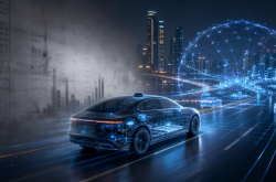
Luxury Lineup, Highly Anticipated! The Pioneer of Physical AI Gears Up for Hong Kong Stock Exchange Debut!
-
![]()
Mercedes-Benz Withholds Year-End Bonuses for 90,000 Staff: Germany's Industry 4.0 Aspirations in Tatters
-
![]()
Can the Hong Kong Stock Market Pay for World Models? Dissecting Momenta's Prospectus
-
![]()
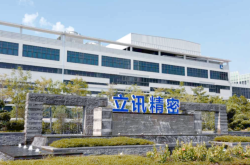
Set for Secondary Listing in Hong Kong with Market Cap Exceeding 500 Billion: How Luxshare Precision Regains Investor Trust?
-
![]()
Approaching its Secondary Listing in Hong Kong with a Market Cap Exceeding 500 Billion: How Has Luxshare Precision Regained Investor Trust?
-
![]()
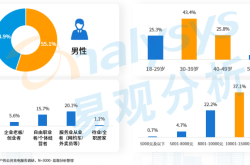
Real Insights from New Energy Vehicle Owners in China’s Top 30 Cities by Ownership
-
![]()
Real Thoughts of New Energy Vehicle Owners in Top 30 Cities by Car Ownership
-
![]()
Truth Revealed: Memory Prices Soar, Apple Profits Surge, Yet Memory Makers Bear the Blame