Seven Questions to Understand True Low-Altitude Applications!
![]() 06/05 2024
06/05 2024
![]() 892
892
At the 2024 National People's Congress and the Chinese People's Political Consultative Conference, "low-altitude economy" was written into the government work report for the first time and will be built as a new growth engine for emerging and future industries, becoming an important representative of new-quality productivity. The integrated sensing and communication capabilities of 5G-A play an irreplaceable supporting role in the low-altitude economy due to their excellent fusion of communication and sensing characteristics. But what exactly is the low-altitude economy? And what is 5G-A's integrated sensing and communication?
Question 1: What is the low-altitude economy, and how low is low altitude?
The low-altitude economy refers to a comprehensive economic form that relies on low-altitude airspace and is driven by low-altitude flight activities of various manned and unmanned aerial vehicles, radiating and driving the integrated development of related fields.
Low altitude usually refers to an airspace within 1000 meters of true height (the vertical distance from an aircraft to its immediate underside), and sometimes it can extend to 3000 meters depending on the characteristics and practical needs of different regions. Currently, the development focus of low-altitude airspace is on non-regulated airspace, specifically airspace with a true height of less than 300 meters, which is mostly used for logistics, inspection, and other industry-grade drones, as well as consumer-grade drones for aerial photography, food delivery, and other purposes. It is currently the key development airspace for low-altitude airspace.
Within this altitude range, there are difficulties such as continuous coverage challenges, high networking costs, and significant network interference for aircraft communications. To address these issues, China Mobile pioneered the 700MHz + 2.6GHz + 4.9GHz low-altitude multi-frequency collaboration, airspace-ground base station reuse, and three-dimensional fish scale networking, reducing the average networking cost to 1/3 and interference by 5-10dB, enabling low-altitude flights to fly unimpeded, regardless of tall buildings.
Question 2: What does the low-altitude industry chain include and which companies are involved?
The low-altitude industry consists of three major sectors, mainly comprising low-altitude aircraft manufacturing, low-altitude infrastructure, and low-altitude application operation services. According to a report by CCID, in 2023, the domestic low-altitude economy reached a scale of 505.95 billion yuan, of which the scale of the three major industries reached 303.57 billion yuan (accounting for 60%), and the indirect economic activities surrounding supply chains, production services, transportation, and consumption reached a scale of 202.38 billion yuan (accounting for 40%). It is estimated that by 2030, the scale of the three major industries in the domestic low-altitude economy will reach 2 trillion yuan.
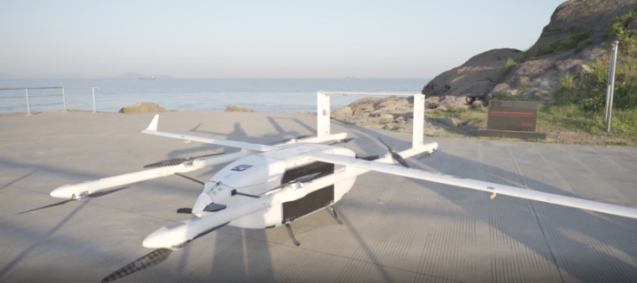
Low-altitude aircraft manufacturing sector: Mainly carriers such as drones, eVTOLs, and helicopters, with the industry developing at a world-leading level. Well-known drone manufacturers such as DJI and EHang belong to the leading companies in this sector.
Low-altitude infrastructure: It is divided into physical infrastructure (general aviation airports, take-off and landing stations, etc.) and new infrastructure. Low-altitude intelligent networking is the key to building new infrastructure. Low-altitude intelligent networking is an intelligent digital network system constructed with the integration of space, ground, and air networks (low-orbit satellites, cellular networks, and ground networks) as the core, achieving unified low-altitude communication, navigation, surveillance, and services. Operators represented by China Mobile are the backbone of building low-altitude infrastructure.
Low-altitude application operation services: They are the key to industrial upgrading. Low-altitude economic application scenarios can be roughly divided into urban and non-urban scenarios. Urban scenarios include flight activities such as logistics and distribution, airport security, air traffic, and flight supervision; while non-urban scenarios include operational flights in remote areas for industries such as industry, agriculture, forestry, fisheries, and construction, as well as emergency communication, medical rescue, agricultural and forestry plant protection, fire rescue, inspection patrols, and tourism.
With the rapid development of the concept of "low-altitude economy," it is believed that low-altitude applications will cover all aspects of people's daily lives in the future, continuously spawning new business formats and models.
Question 3: How is 5G-A's integrated sensing and communication applied in the low-altitude field?
Currently, the development of the low-altitude economy is still in its early stages. Realizing interconnection between different systems and real-time sensing of critical information for aircraft is the basis for ensuring safe and efficient low-altitude flights. This includes strengthening the communication coverage capabilities and sensing management of low-altitude aviation equipment. To address these issues, integrated sensing and communication technology has come into view.
Integrated sensing and communication is one of the signature technologies of 5G-A. It integrates capabilities such as communication, sensing, and computing power, enabling communication networks to possess radar-like detection, tracking, and sensing capabilities. In the low-altitude field, it can achieve real-time monitoring and tracking of low-altitude flying objects such as drones, birds, and floating objects (balloons, kites, sky lanterns), capturing and calculating the distance, speed, and trajectory of target objects to ensure safe and efficient low-altitude flights.
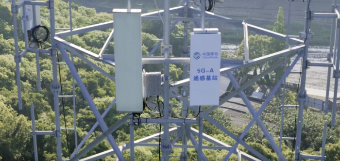
However, there are challenges in applying integrated sensing and communication in the low-altitude field, such as difficulties in network signal coverage and large errors in sensing accuracy. To address these issues, China Mobile innovatively proposed the "double-layer phase-shifting super-wide-angle new hardware," leading the industry to expand from the traditional 24° vertical beamwidth to over 60°. While maintaining ground coverage capabilities, it extends communication and sensing capabilities to 300-meter low altitude, laying a hardware foundation for establishing a ground-air three-dimensional network. In terms of sensing management, based on the design concept of collaborative promotion of multi-service integration between 5G-A and 6G, China Mobile has created a "Master + Slave two-level BBU new architecture" to achieve centralized correlation, fusion trajectory deduplication, and joint result reporting for sensing target management solutions, achieving high-precision and high-certainty sensing within a wide range, including the low-altitude field.
Question 4: Why is integrated sensing and communication considered the "eye" of drones?
Traditional drone sensing methods rely on cameras and sensors, often limited by line of sight and weather conditions. However, integrated sensing and communication technology is different. By fusing communication and sensing capabilities, it endows drones with perception beyond vision. Whether it's day or night, clear skies or rain and fog, it can provide drones with clear and continuous environmental information. Through comprehensive monitoring of low-altitude airspace, integrated sensing and communication effectively prevents drones from colliding in the air or with other flying objects, ensuring the safety of drones and ground personnel.
On the path of sensing technology, China Mobile has taken the lead in exploring implementation solutions based on 4.9GHz low-frequency integrated sensing and communication technology, carrying out large-scale pilot verification work in multiple provinces, striving to create industry application demonstration benchmarks in the low-altitude field.
Currently, China Mobile's integrated sensing and communication solution based on 4.9GHz has more prominent technical advantages. Firstly, the 4.9GHz frequency is a commercially licensed band, while millimeter-wave licenses have not yet been officially issued. Secondly, under low-altitude scenarios, the 4.9GHz frequency offers better cost-effectiveness, achieving longer coverage distances and lower networking costs under the same sensing accuracy requirements, while millimeter waves only have slight advantages near base stations, with overall accuracy comparable to 4.9GHz. Thirdly, the industrial maturity is better, with the relevant industry chain supporting 4.9GHz being more mature than millimeter waves, and base stations and terminal applications being more widespread.
Question 5: How are drones managed?
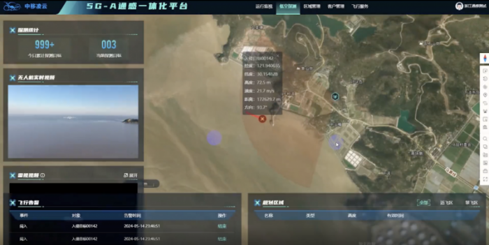
Typically, drones are centrally managed and controlled through a management platform. For example, China Mobile's independently developed drone supervision intelligent platform specifically designed for low-altitude supervision scenarios possesses advanced technical capabilities such as low-altitude aircraft trajectory display, high-precision flight path comparison, and regional alarm, providing more possibilities for the widespread application of drones in areas such as emergency rescue, police security, environmental surveying and mapping, and industrial energy.
The China Mobile Lingyun low-altitude supervision service platform utilizes integrated sensing and communication and visible light AI recognition technology to precisely identify and visually track flying drones, providing intuitive and real-time observation, decision-making, and evidence collection support for regulatory departments.
Question 6: In which cities has China Mobile established low-altitude benchmarks?
With the introduction of promotion policies by national ministries and commissions such as the Ministry of Transport and the Ministry of Industry and Information Technology, local governments have also rolled out relevant guidelines for the low-altitude field. To date, China Mobile has implemented low-altitude applications in various industries in multiple provinces and cities, including Guangdong, Jiangsu, Zhejiang, Hebei, Yunnan, and Fujian.
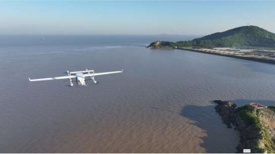
In Zhoushan, Zhejiang, China Mobile, in collaboration with industry partners such as Fengyi, took the lead in applying 5G-A integrated sensing and communication 128T commercial base stations to low-altitude drone seafood transportation routes in Zhejiang and Shanghai, innovatively achieving real-time sensing and monitoring of precise data such as drone altitude, position, and trajectory dynamics using 5G-A integrated sensing and communication technology.

In Baoshan, Yunnan, China Mobile collaborated with Baoshan Airport to carry out low-altitude real-time sensing and target dynamic tracking, pioneering the creation of a low-altitude integrated sensing and communication smart airport, building active and real-time interactive perception safety monitoring capabilities, automatically identifying and warning potential safety hazards, and achieving an upgrade from "human defense" to "technical defense".
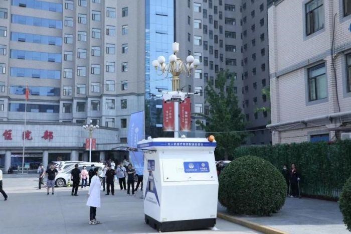
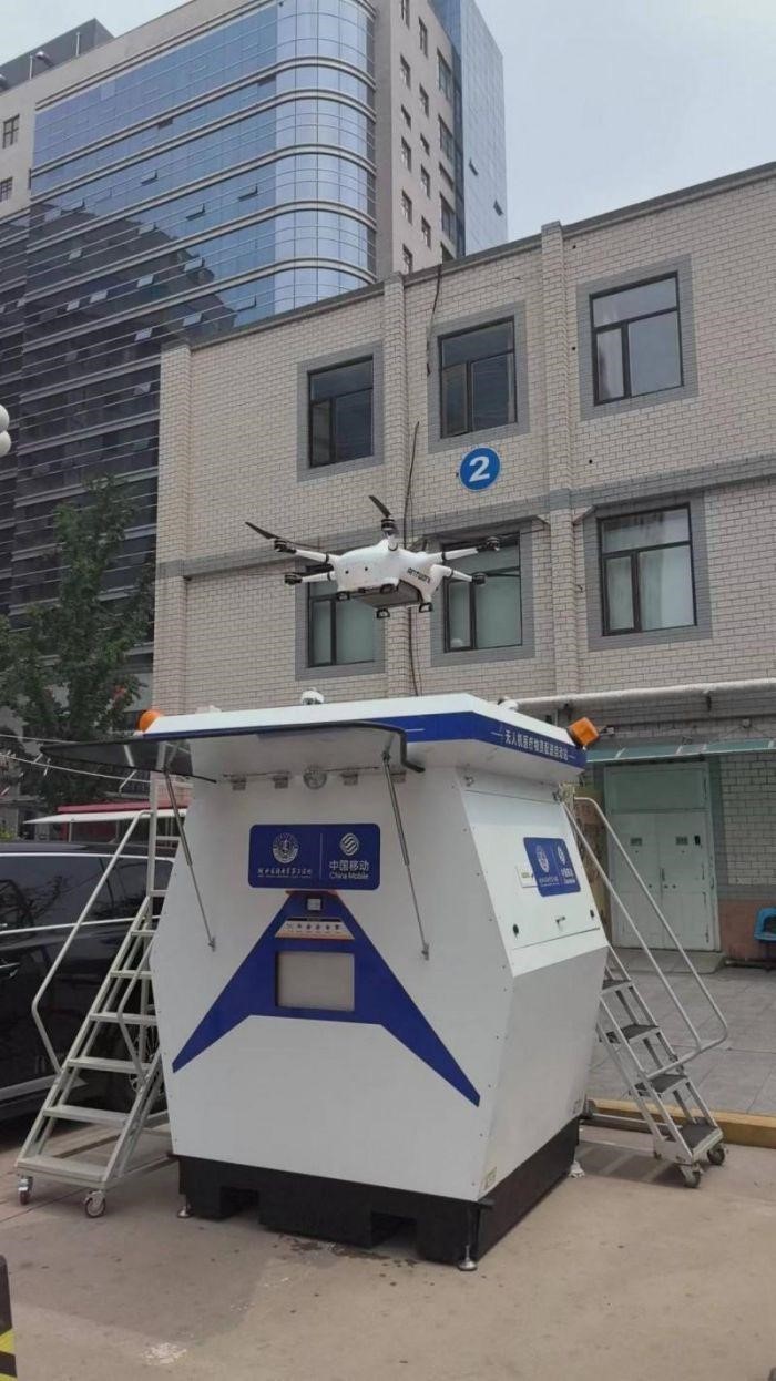
In Shijiazhuang, Hebei, China Mobile collaborated with the Provincial Third Hospital to carry out a drone integrated sensing and communication blood transportation project, completing the first flight of 5G-A drone emergency medical material transportation in Hebei Province. Through the combination of "5G-A + blockchain + AI" technology, using integrated sensing and communication drones, it successfully achieved efficient low-altitude blood distribution between hospitals and blood stations, empowering medical rescue with 5G-A and injecting new momentum into the development of smart healthcare.
Question 7: What are China Mobile's plans for the next step in the low-altitude and 5G-A fields?
In the future, China Mobile will continue to promote the development of the low-altitude economy from multiple aspects such as technology evolution, application scenarios, and industrial prosperity. Recently, a significant move is the "Low-Altitude Economy and 5G-A Industry Application Sub-forum" hosted by China Mobile, which will be held in Beijing at 9 am on June 6. Don't miss it!


