How can we elevate autonomous driving scene understanding from 2D to 3D?
 04/27 2026
 450
450
The core mission of autonomous driving is to equip machines with the ability to observe, think, and operate vehicles just like humans. Within the entire technological architecture, perception and scene understanding are at the forefront, serving as the foundation for all subsequent decision-making and execution logic.
If we liken an autonomous vehicle to a living organism, sensors are akin to nerve endings distributed throughout its body, while scene understanding capabilities represent the brain's deep processing of these neural impulses. This processing not only requires the vehicle to perceive its surroundings but also to comprehend the spatial relationships, semantic attributes, and potential future behaviors of objects within those surroundings.
With continuous technological advancements, autonomous driving scene understanding has evolved from simple 2D image recognition to 3D spatial reconstruction, and even to a cognitive stage with common-sense reasoning capabilities.
From Multi-Dimensional Perception to Spatiotemporal Alignment
Before delving into algorithmic models, it is essential to understand the hardware foundation upon which autonomous driving acquires information. A single sensor, constrained by its physical properties, cannot handle all weather and lighting conditions.
Cameras provide rich color and texture information but perform poorly under direct strong light, darkness, or foggy conditions. LiDAR outputs high-precision 3D point cloud data, clearly outlining obstacle contours, yet struggles to identify traffic light colors or text on road signs. Millimeter-wave radar excels in penetrating adverse weather and is sensitive to the speed of dynamic objects, but its low spatial resolution makes it difficult to discern details of stationary objects.
Therefore, multi-sensor fusion technology has become the first technical hurdle in scene understanding.
Multi-sensor fusion is not merely about adding information together; its core lies in resolving inconsistencies in time and space across different sensors.
Spatially, each sensor has its own coordinate system. Cameras perceive pixel coordinates, while LiDAR perceives polar or Cartesian coordinates. The system must employ extremely precise external calibration to unify all data into a fixed vehicle world coordinate system.
Temporally, different sensors have varying sampling frequencies, and due to the vehicle's high-speed motion, even a Several tens of milliseconds ( Several tens of milliseconds : dozens milliseconds) difference can result in significant changes in an object's position in real space.
To address this, the system employs motion compensation techniques, aligning data from different moments based on the vehicle's motion state to ensure that all information reflects the environmental state at the same physical moment.
Depending on the stage at which data fusion occurs, the industry categorizes it into front fusion, deep fusion, and back fusion.
Front fusion integrates data at the raw data level, preserving the most bottom layer ( bottom layer : underlying) information but demanding extremely high computational power and bandwidth.
Deep fusion occurs during the feature extraction stage of neural networks, connecting or weighting feature vectors from different modalities in feature space. This approach enables information complementarity and enhances system robustness.
Back fusion involves independently deriving detection results from each sensor before logically aggregating them. Although simple in architecture and highly flexible, it often loses critical detailed information due to the limitations of individual sensors.
In urban road environments, real-time and accurate perception of the dynamic environment is a prerequisite for safe vehicle decision-making.
The perception system relies on the collaborative operation of multiple technological modules, including sensor data acquisition, feature extraction, data fusion, and semantic analysis.
Data acquisition is the starting point, where collaboration among various sensors enables comprehensive perception needs from long-range to short-range.
Subsequent feature extraction employs complex algorithms to extract valuable information from raw data, such as detecting vehicle boundaries, segmenting pedestrian contours, and identifying road signs.
Architectural Innovations in Bird's-Eye View and Occupancy Networks
After resolving the unification of sensor data, the next step is to extract meaningful geographical structures from this vast amount of data.
Traditional perception methods primarily rely on image-level object detection, drawing boxes in photographs. However, this approach struggles to accurately describe an object's true pose in 3D space, especially in areas where multiple camera views overlap, posing a significant challenge in ensuring correct image stitching from different perspectives.
The emergence of Bird's-Eye View (BEV) technology has revolutionized this landscape. BEV perception schemes fuse visual data from multiple cameras, projecting fragmented 2D images directly onto a unified 3D bird's-eye perspective to generate global environmental information.
The core of BEV technology lies in spatial transformation.
The system first utilizes deep learning networks to extract features from each camera's raw images. These networks include a backbone network for feature extraction, a neck network for feature fusion, and a head network for generating detection results.
The extracted features then undergo a mathematical mechanism akin to projection, querying positions in 3D space. This process can be visualized as the system installing a virtual camera on the ceiling above the vehicle, using algorithms to calculate the corresponding pixels of each point on the ground in different raw images, thereby completing the conversion from a 2D plane to 3D geographic coordinates.
This technology effectively addresses occlusion issues because even if an object is partially blocked in a side camera's view, as long as other cameras' fields of view cover that area, the system can fully restore its position and trajectory in the view.
However, even BEV technology struggles with irregularly shaped objects. Items like overhanging tree branches, construction site barriers, or scattered cargo on the ground are difficult to accurately describe using standard cubic boxes.
To address these challenges, Occupancy Networks have emerged. Instead of attempting to identify what an object is, Occupancy Networks divide the space around the vehicle into countless tiny cubic grids, predicting whether each grid is occupied and its motion state.
Occupancy Networks elevate scene understanding from a classification task to a spatial geometric reconstruction level.
By predicting the occupancy probability of each point in space, they can identify any irregularly shaped obstacles, even if the system has never encountered such objects before. This predefined category-independent characteristic significantly enhances the generalization ability of autonomous driving in complex urban environments.
To improve computational efficiency, current Occupancy Networks incorporate semantic segmentation techniques, simultaneously determining spatial occupancy and providing semantic labels for the area, such as identifying one occupied grid as vegetation and another as a curb.
Furthermore, this 3D spatial understanding capability provides a more reliable basis for downstream path planning.
Traditional perception results, if merely 2D, make it difficult for the planning system to determine whether the vehicle can pass through a narrow gap. With voxelized spatial representation, the system can precisely calculate the physical distance between the vehicle's contour and obstacles, enabling more nuanced driving maneuvers.
To tackle challenges posed by various extreme weather and lighting conditions, the perception system has undergone multi-layer optimizations in hardware design and algorithmic robustness, ensuring rapid processing of vast amounts of data and accurate identification results in complex driving scenarios.
How Foundation Models Endow Machines with Driving Common Sense
Although BEV and Occupancy Networks have enabled autonomous vehicles to perceive the physical world, they still appear mechanical when facing complex traffic rules and unpredictable social interactions.
For instance, when a human driver encounters an ambulance with flashing red lights, they know to observe the road conditions and yield as much as possible, even if it means running a red light. When seeing a toddler walking unsteadily by the roadside, humans anticipate that the child might suddenly run onto the road.
These common-sense logical reasonings are difficult for traditional rule-based algorithms to fully cover. In recent years, foundational models, centered around large language models and visual language models, have been introduced into the autonomous driving field to address these deep-seated semantic understanding and reasoning issues.
The core of foundational models in autonomous driving lies in their possession of world knowledge.
These models have learned the operational laws of human society from massive text and image data, enabling them to understand complex causal relationships. For example, when facing a construction zone, a foundational model can not only identify cones and barriers but also infer the best detour route based on current traffic flow and road sign text.
Compared to traditional decision-making methods based on logic trees, this model-based approach demonstrates strong generalization ability when handling unseen special scenarios. It expands the scope of perception from identifying geometric shapes to understanding scene intentions.
In terms of specific implementation logic, these models adopt a multimodal architecture, transforming visual sensor feature information into textual descriptions or high-dimensional vectors for interaction with a pre-trained knowledge base. Through this approach, autonomous driving systems can achieve a logical chain similar to human thinking.
If the vehicle perceives the taillights of the vehicle ahead flashing, combined with the current intersection characteristics and lane topology, it can infer that the vehicle may be stopping due to a malfunction or preparing for an emergency lane change, ultimately deciding to slow down and maintain a safe distance.
This reasoning process is no longer merely probabilistic calculation but possesses a certain degree of interpretability, allowing people to understand why the vehicle made a specific choice at a particular moment.
Foundational models also play a crucial role in scene generation and system evaluation.
By mass-generating rare extreme scenarios, such as non-motorized vehicles running against traffic at night or reflective puddles reflecting light on rainy days, these models provide high-quality, multidimensional simulated data for training autonomous driving systems, accelerating the iterative optimization of perception.
This closed loop of extracting knowledge from real data and feeding it back to the system through simulated data is becoming an important path to enhance autonomous driving scene understanding capabilities.
To achieve safe driving in real urban traffic, the system also employs multi-criteria decision-making methods to balance multiple objectives, including safety, comfort, and efficiency, ensuring that the vehicle can naturally integrate into the traffic ecosystem.
Final Thoughts
Autonomous driving scene understanding is an evolutionary process that spans from physical detection to mathematical reconstruction and further to cognitive reasoning. From the data foundation laid by multi-sensor fusion to the Stereoscopic field of view ( Stereoscopic field of view : three-dimensional perspective) constructed by bird's-eye view and occupancy networks, and finally to the intelligent brain endowed by foundational models, each technological breakthrough bridges the capability gap between machines and human drivers.
In this process, scene understanding has evolved beyond merely seeing; it has become an insight into the laws of the physical world. With continuous improvements in computational power and iterative advancements in algorithmic models, all-scenario, highly reliable semantic understanding will eventually be achieved, providing the most solid guarantee for the safe implementation of autonomous driving.
-- END --
-
![]()
Tesla Restructures Its Balance Sheet
-
![]()
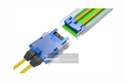
Accelerating the High-Speed Interconnection Upgrade of AI Computing Clusters! JONHON Releases ELSFP External Light Source Optical Connectors
-
![]()
Breaking the overseas blockade of volumetric holographic materials, this optical enterprise secures nearly 100 million yuan in financing!
-
![]()
Why Does Jensen Huang So Openly Praise China’s AI?
-
![]()
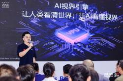
"Wudang" Unveiled: Arm China's Next-Gen AI VPU Redefines Video Encoding
-
![]()
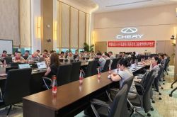
From Energy Conservation and Carbon Reduction to AI Decision-Making: GECON East Intelligence and Chery Group Explore a New Green and Smart Paradigm for Automobile Manufacturing
-
![]()
WAIC 2026 Observation | AI Accelerates Towards the Core of Industries, Industrial AI Enters a Critical Phase
-
![]()
Volkswagen China Fires the First Shot in Foreign-Funded 'White Box Delivery'!